
A series of hydrothermal cobalt polymetallic deposits in northeastern Hunan Province occurr along the Changsha-Pingjiang fault zone,the middle section of the Jiangnan orogen belt. These deposits are hosted in the tectonic-hydrothermal alteration belt at the footwall of the Changsha-Pingjiang fault zone,and controlled by the fault zone and its secondary structures.However,the occurrence state of cobalt and cobalt-containing minerals in the whole belt isn’t sufficient,which restricts the understanding of the metallogenic process of cobalt in the belt.The detailed mineralogical observation,TIMA analysis and EPMA showed that the pyrite is the main sulfide and also an important cobalt-containing mineral in the Hengdong deposit.It exhibits a complex textural characteristics,that is,the cobalt-rich pyrite with silk-shaped,ring-shaped or irregularly at the edge replaced by the cobalt-poor pyrite at the core.The cobalt-rich pyrite has a clear oscillating zone exhibits high Co (up to 3.52%) but low Ni contents (≤0.09%). The complex zoning indicated that fluid-coupled dissolution and precipitation mechanism was responsible for the formation of Co-rich pyrite. In comparison,cobaltite ore is the most important cobalt-bearing mineral in the Jintang cobalt polymetallic deposit,which is closely related to pyrite,marcasite,and arsenopyrite,and occurs as an isolated granular form or wrapped in arsenopyrite particles.The particle size of cobaltite is between 3 μm and 45 μm. The contents of Co,Fe,and Ni of cobalt vary from 9.51% to 23.21%(average is 15.50%),4.33% to 17.66%(average is 9.46%),and 5.52% to 15.24%(average is 9.31%),respectively.Combied with the occurrence form of cobalt in the Jingchong cobalt-copper polymetallic deposit,it could be concluded that the cobalt-containing minerals vary from cobaltite to pyrite along the Changsha-Pingjiang fault zone from southwest to northeast.Furthermore,the Co contents in cobaltite increases tend to while Ni contents decreases,and the high content of Co in pyrite decreases.The mineralizing disparity could be explained by controlling factors such as ore-forming fluid migration direction and physical-chemical conditions(e.g.,pH value and fS2). Combined with Co(-polymetallic) orebodies controlled by the NE-trending Changsha-Pingjiang deep fault zone,it was proposed that the southwestern part of the deep fault in Lianyunshan area would be the focus of next cobalt exploration in northeastern Hunan Province.

As an important geological prospecting method,geochemical survey has been widely used in regional mineral prospect survey with its fast and efficient characteristics,and has achieved good geological prospecting results.At present,the main methods used include river sediment survey,soil survey,rock survey,etc.The southern belt of Beishan,Gansu Province,is an important metallogenic belt in the Beishan area of Gansu Province,belonging to the arid desert Gobi landscape area,with poor natural conditions and low degree of geological work.In the area,the development of river system is generally short,and the primary and secondary river systems are the main ones. The river sediment can well reflect the mineralization information in the catchment area. The 1∶50 000 stream sediment survey was carried out in the selected blocks in the research area,and the content information of 14 elements in the research area was obtained,such as Au,Ag,Cu,Pb,Zn,Co,Ni,Hg,Sb,As,Mo,W,Sn,Bi. The obtained geochemical data were processed in combination with the strata,structure,and distribution of magmatic rocks in the research area.The elements in the research area have obvious classification characteristics,in which Au,Ag,As,Sb,Hg are a group of medium-low temperature hydrothermal elements,Cu,Pb,Zn,Mo,Ni,Co are a group of medium-high temperature hydrothermal elements and basic elements in basic and ultrabasic rocks,which are related to hydrothermal activities and basic and ultrabasic dikes controlled by NW and NE trending fault structures in the research area.W,Sn and Bi are a group of high-temperature element combinations,representing W mineralization in the research area.According to the distribution characteristics of the elements and the geological background,five comprehensive anomalies were delineated in the research area,including two Class B1 anomalies,two Class B2 anomalies,and one Class C3 anomaly. Through the general inspection and key inspection of the anomalies,Huayaoshan tungsten deposit was found in the HS-3 anomaly,and Dakouzi Dongshan tungsten deposit and Huayaoshan toxic placer deposit were found in the HS-4 anomaly.In the research area,three prospecting prospects with tungsten ore as the main ore were divided.It shows that the measurement of stream sediment has good geological prospecting effect in the southern belt of Beishan,and provides basic data for further geological prospecting work in the research area. At the same time,combined with the geological prospecting results in the southern belt of Beishan in recent years,the authors comprehensively analyzed the metallogenic geological background,metallogenic environment,mineralization,and metallogenic law in the research area,and put forward new prospecting directions and suggestions for the next step,which has reference significance for carrying out mineral prospecting in the arid desert Gobi natural landscape area of Beishan in Gansu Province.

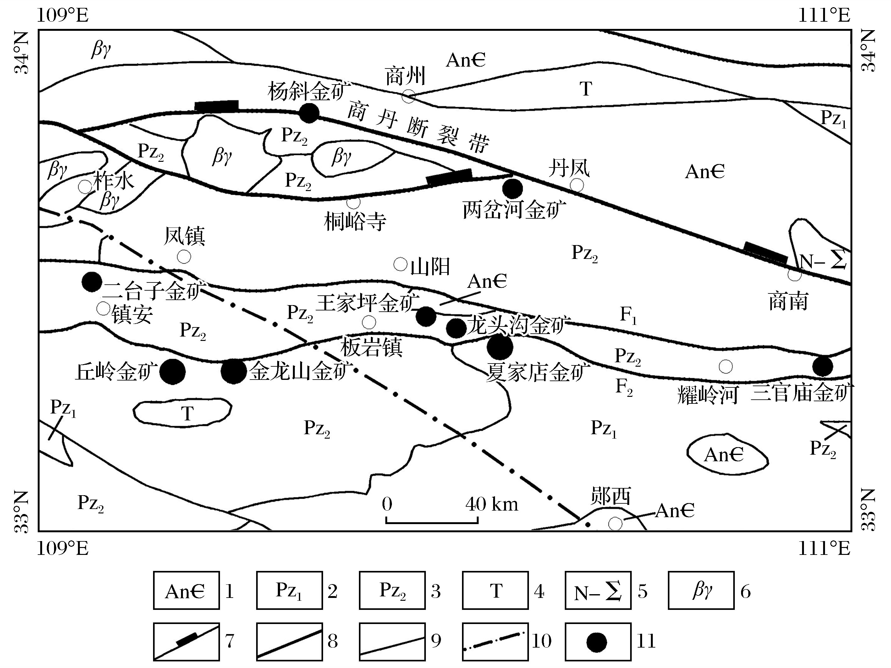
In recent years,many types of gold deposits have been found in Wangjiaping-Shangnan area,Shaanxi Province.Due to the lack of detailed antomy of the typical deposits in the region,and insufficient understanding of the ore-controlling factors,occurrence regularity,and genesis of the regional gold deposits,the metallogenic regularity and propecting direction in the region are not clear,which restricts the propecting breakthrough in this area.On the basis of investigating the regional geological structure background,the geological characteristics,ore-controlling factors and ore-bearing laws of typical gold deposits in Wangjiaping-Shangnan area were systematically sorted out.Combined with the characteristics of fluid inclusions in typical gold deposits,the spatial distribution characteristics,metallogenic conditions and the occurrence and mineralization patterns of gold deposits(points)in the area were summarized.The results show that the gold deposits(points) in the area are controlled by the nearly EW-trending Shanyang-Fengzhen fault,Zhen’an Banyanzhen fault,or their secondary fault belts.They are developed in the interlayer faults of specific strata and controlled by dual factors of faults and strata,the gold deposits(spots)in the area are generally enriched in the nearly EW-trending zonal segmentation.The gold orebodies in different sections are controlled by different forms of faults and overall lenticular output.According to the metallogenic characteristics,ore-controlling factors and metallogenic regularity of the mining area,the prospecting prediction model of gold deposits in the area was established,and five prospecting target areas were predicted in combination with the distribution range of strata,structures and geochemical anomalies,which provides new ideas and new directions for the next step of ore exploration work in the area.
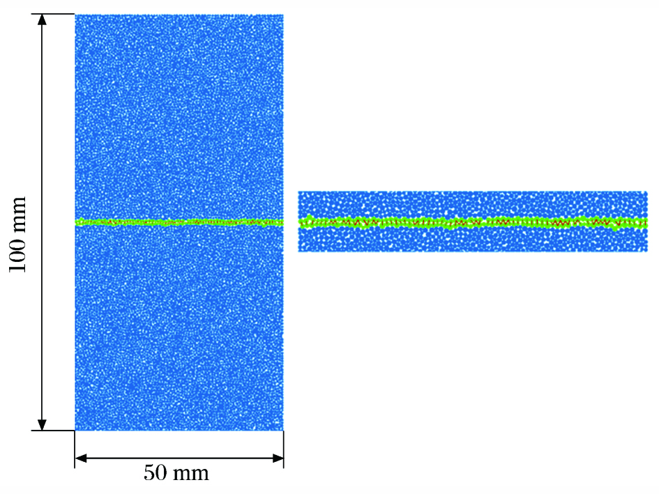
Rock joints have significant influence on the propagation of stress waves in jointed rock mass.Study on the propagation law of stress waves in jointed rock mass is of great practical significance and theoretical value for rock blasting,earthquake engineering and explosion protection.The code was written by FISH language to modify the normal stiffness of micro-joints in the smooth joint model,and a particle flow model of rock joints with nonlinear deformation characteristics was established.The propagation characteristics of stress waves across single nonlinear deformed joints were analyzed,and the influence laws of joint stiffness,stress wave amplitude and stress wave frequency on the transmission and reflection coefficients were obtained.The interaction mechanism between stress wave and joint was revealed from microscopic perspective.The results show that the joint equivalent stiffness has a great influence on transmission and reflection coefficients of the stress wave.The larger the equivalent stiffness is,the larger the transmission coefficient is,and the smaller the reflection coefficient is.When the joint stiffness reaches a certain critical value,the transmission coefficient increases slowly and tends to a constant value.With the increase of the amplitude of incident wave,the transmission coefficient is increasing and reflection coefficient is decreasing.The stress wave transmission coefficient decreases with the increase of incident wave frequency,and the joint shows high frequency filtering.
Canister for high-level radioactive waste is a core part in nuclear waste disposal barrier,and its static and dynamic stability during transportation,installation,and deep buried operation is of great importance.A silicon carbide(SiC) material based canister was proposed in this paper.The material has remarkable chemical stability,but its brittleness may be the key to restrict it application.In oder to investigate the static and dynamic stability of this canister,series of numerical simulations were performed using discrete element method,considering the physical nature of rock blocks and characteristics of interactions between rock and canister.The tensile strength characteristics of SiC was first investigated via specially designed lab and numerical tests.Comparison with analytical results has proved the reliability of adopted numerical method.The influence of disposal depth and horizontal to vertical stress ratio was then investigated.The dynamic loading behaviour pattern and basic failure mode of canister under free fall and rock impact were investigated,and the influence of rock fragmentation was mainly considered.The results show that the silicon carbide material is relatively brittle,with tested tensile strength between 150 MPa and 200 MPa,compared to its very high compressive strength.The tensile strength of silicon carbide was chosen 150 MPa for safety reason in later analysis.However,this value of 150 MPa is higher than the tensile or even compressive strength of ordinary rocks.The canister can survive under 1 200 m depth,horizontal to vertical stress ratio of 3 with several disposal inclination angles.Under free fall,the maximum tensile stress in canister is determined by falling height and inclination angle.Upon rock fall without rock splitting,the maximum tensile stress in canister is determined by rock weight and contact type between rock and canister.Inclusion of rock splitting in model calculation can produce stress much lower than by traditional continuum method.The tip of the rock will crack first once the rock is hitting the canister,leaving the canister safe in the first place,which is different from that in continuum analysis.This implies the energy dissipation between rock blocks due to fracturing of rock during rock impact is not negligible.As the cohesion and residual friction angle between rock blocks increase,the stress induced in canister also increases,while the tension makes limited contribution to elevated stress.Another interesting finding is that as the rock block volume ratio gets smaller,the stress induced by impacting rock decreases first but then keeps to a constant value once certain threshold is reached.This suggests by reaching certain rock block volume ratio may be enough to reproduce dynamic impact-induced cracking,instead of decreasing rock block size constantly.Although local failure is expected under dynamic impact,a soft buffer layer with certain thickness outside the canister can guarantee static and dynamic stability of SiC canister together with appropriate emplacement.

As a type of slow-change geological hazard,ground subsidence have an important impact on people’s production and life.Since the establishment of Global Positioning System (GPS) monitoring of ground subsidence within the impact area of underground mining at Sanshandao gold mine in September 2012,significant ground subsidence has been monitored.In order to grasp the characteristics and patterns of ground subsidence in the mine area,this paper obtained the spatial and temporal variation of ground subsidence in the Sanshandao gold mine area by summarizing and analyzing the results of previous multi-period monitoring,and briefly discussed the direct and indirect factors causing the ground subsidence phenomenon,and finally proposed suggestions to mitigate the ground subsidence in the mine area.The results show that:(1)The trend of the subsidence extent in the study area is consistent since September 2012,and the center of subsidence is located in the upper disk area of the orebody,500 m to 600 m east of Sanshandao village committee. (2)The morphology of the ground subsidence basin has evolved from a nearly circular shape at the beginning to an elliptical shape at a later stage,i.e.,along the southeast side of the subsidence basin. (3)The subsidence contours are denser on the side close to the F1 ore-control fracture and sparser on the side far from the F1 fracture. (4)The cumulative sedimentation value of the sedimentation center becomes larger and larger over time,and the sedimentation velocity changes significantly,with a faster sedimentation velocity at first,then a slower sedimentation velocity,and an increase in the sedimentation velocity in recent years.According to the settlement velocity,the cumulative settlement curves can be divided into three stages.The first stage,between September 2012 and September 2016,the cumulative settlement is about 337 mm,with an average annual settlement of about 84 mm.The second stage,between September 2017 and September 2020,the cumulative settlement is about 73 mm,with an average annual settlement of about 24 mm.The third stage,from September 2020 to September 2021,the average annual subsidence is approximately 68 mm.The ground subsidence of Sanshandao gold mine is the product of the combined effect of mining disturbance force and self-gravity of the overlying rock.The movement deformation of the overlying rock in the mining area and the compression deformation of the overlying softer quaternary sediments will lead to the ground subsidence.The direct mining influences on ground subsidence can be divided into the shape of the orebody deposit,depth of burial,geological stress environment,presence of faults,and infill mining methods,while the indirect non-mining influences can be summarized as anthropogenic social factors,i.e.,the ground subsidence phenomenon is also aggravated by the economic development of mining,the increase of buildings,and the pumping of groundwater.

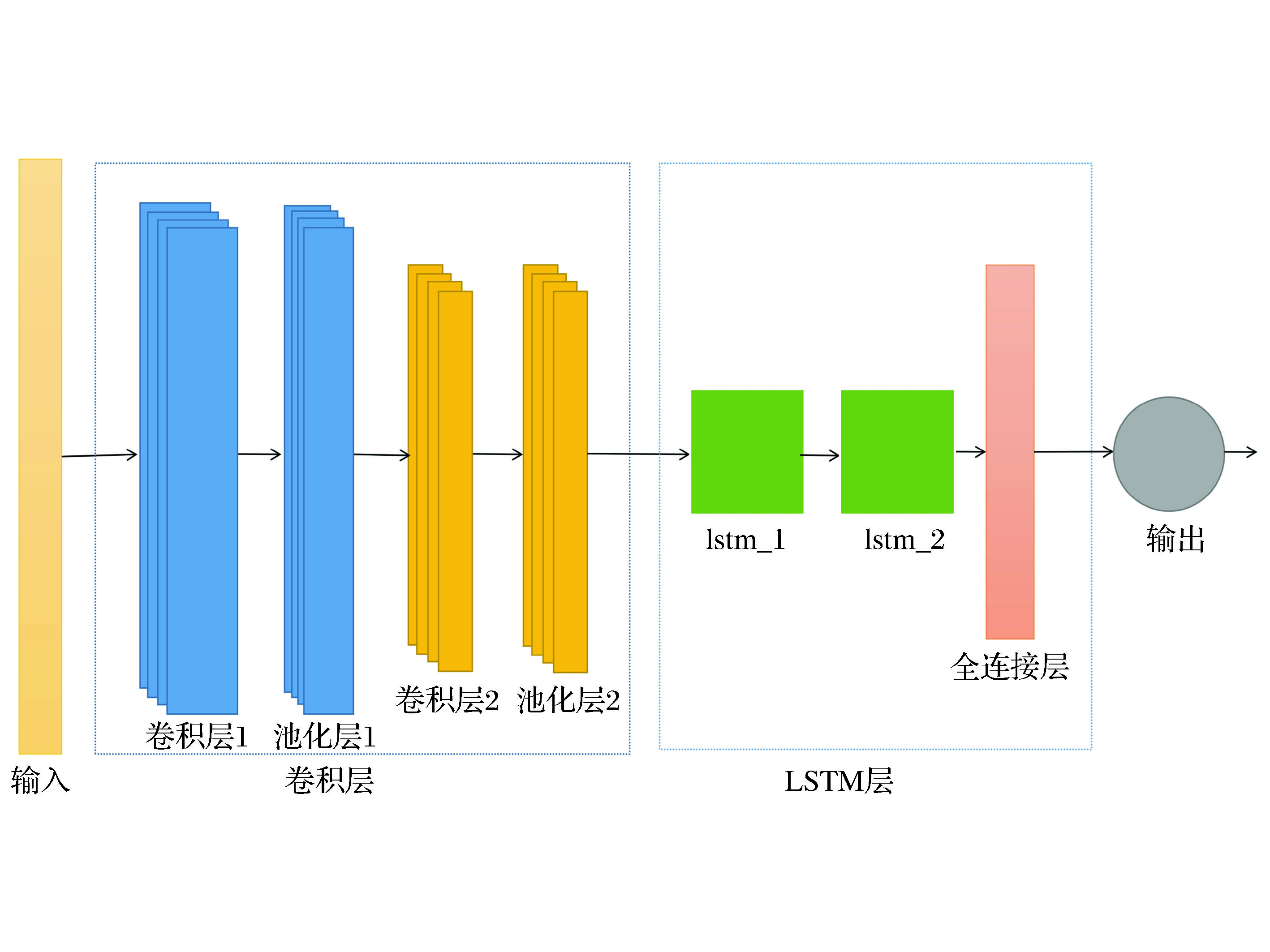
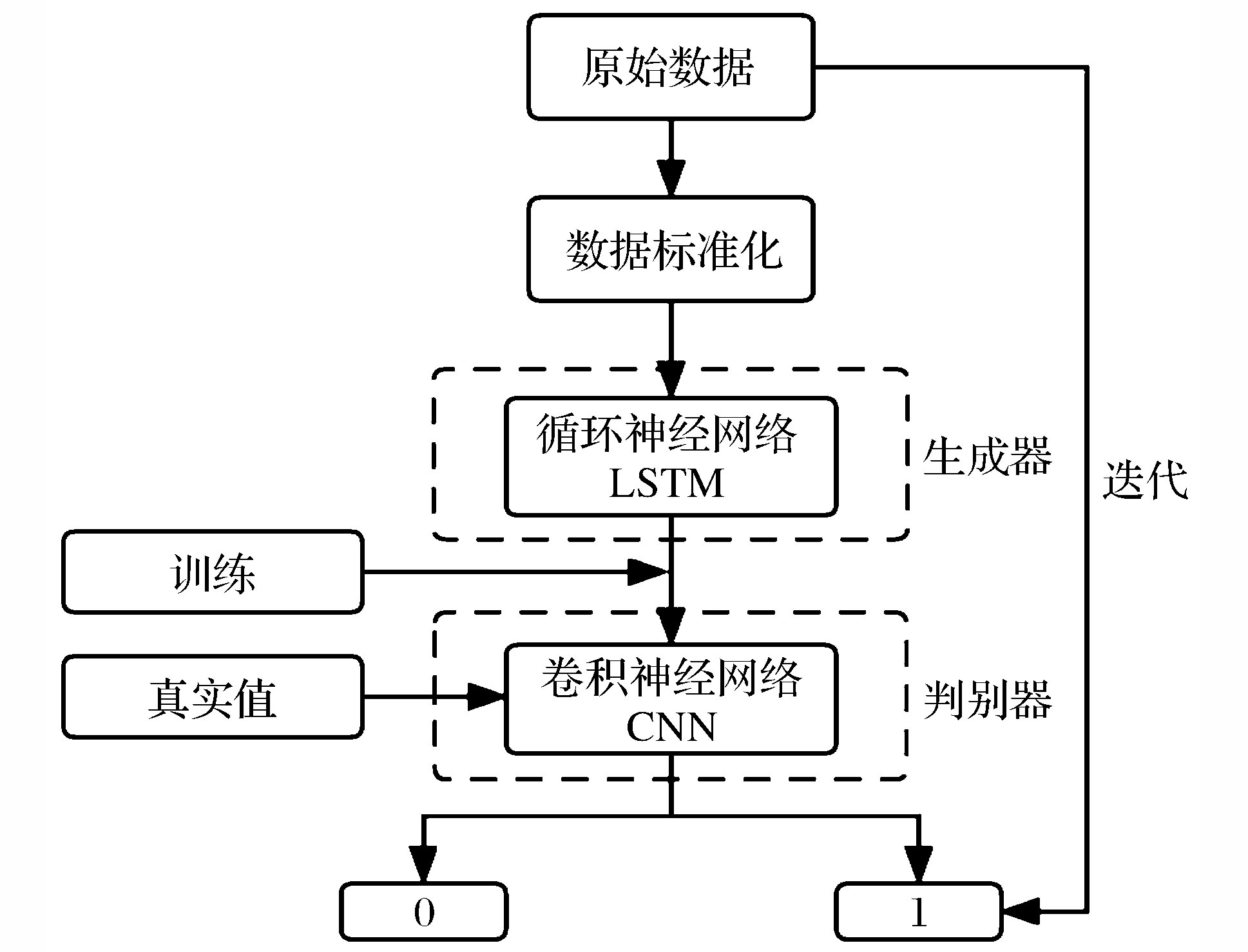
When the traditional limit equilibrium method is used for slope reliability analysis,because of the performance function is implicit and the form is complicated,the iterative process of solving the function becomes complicated and the computational efficiency is low.Aiming at the above problems,a CNN-LSTM model method was proposed.The principle of this method is to first extract the data features by using convolutional neural network(CNN),and then predict the slope failure probability by using short and long time memory network(LSTM).On the basis of fully considering the value range of the CNN-LSTM model’s hyperparameters,the five-factor and four-level orthogonal test table was used to design the hyperparameters.Finally,the convolutional output dimension of the first layer and the second layer of the CNN network architecture in the CNN-LSTM model were determined to be 64 and 8 respectively.Dropout ratio is 0.5,the number of the first layer of the LSTM structure is 5 units and the number of the second layer of hidden layers is 20 units,respectively.The 420 slope sample data collected from central and western regions of China were used to train the model according to the ratio of 7∶3 between the training set and the verification set,and the optimal parameters of the CNN-LSTM model were obtained. Finally,Yanshanji landslide was taken as an example to illustrate the feasibility of the model method.The CNN-LSTM model was compared with Monte Carlo method(MCS),response surface method,single CNN,LSTM model and multiple linear regression model in terms of computational efficiency and failure probability prediction.The results show that:(1)When the MCS sampling times is 10 000,compared with the traditional MCS,although the CNN-LSTM model has a relative error of 4.35% in predicting the slope failure probability,in terms of computational efficiency,the CNN-LSTM model takes 45.28 s and the MCS takes 119 s,so the CNN-LSTM model increases the efficiency nearly 2 times.(2)When the single CNN model and LSTM model both adopt two-layer architecture,although the number of parameters of the CNN-LSTM model is not optimal,it has excellent performance in terms of calculation time and prediction accuracy of failure probability due to the small overfitting risk of the model.Compared with the multiple linear regression model,the relative error of CNN-LSTM prediction is 4.35%,and that of multiple linear regression is 34.78%.Through the above two points,the CNN-LSTM model can well complete the analysis of slope reliability,and avoid solving the implicit performance function,and the work efficiency is high.
The vibration caused by blasting is likely to cause instability and failure of facilities such as underground roadways,high and steep slopes in mining areas or ground buildings under dynamic action.Therefore,it is particularly important to predict the intensity of blasting vibration.The accurate prediction of peak particle velocity(PPV) is the premise of effectively controlling the vibration hazard of blasting engineering,but the current empirical formula for predicting the peak particle velocity is not accurate enough.Machine learning has obvious advantages in solving the problem of nonlinear relationship.In order to improve the prediction accuracy of the PPV prediction model,this study proposes to optimize the number of trees and the minimum number of leaf points in the random forest (RF)by slime mould algorithm (SMA) ,which overcomes the inability to obtain the optimal hyperparameters by using a single RF algorithm.Based on a dataset of 23 samples with four input parameters (minimum resistance line-r,height difference-H,maximum segment dose-Qmax,horizontal distance-W) and one output parameter(PPV) collected in an open-pit blasting engineering example,the combination of four parameters of these four parameters (Qmax-H-W-r、Qmax-H-r、Qmax-W-r、Qmax-r) was used as the input parameters in the RF algorithm,and then MAE,RMSE,MEDEA and R2 evaluate the prediction effect of the SMA-RF model for four different input parameters to determine the optimal combination of parameters.In this model,the fitness function in SMA is defined as the root mean square error of the predicted value to enhance the robustness of the RF model.Then,the performance of SMA-RF model and unoptimized RF model and six empirical formulas commonly used in China and abroad were compared.The results show that the SMA-RF model has better prediction accuracy than the RF model,and the SMA-RF model has significantly better prediction effect than the six empirical formulas.In addition,Qmax-H-W-r can train the optimal SMA-RF model in the combination of four parameters,so it is recommended to be used to predict PPV in engineering practice.

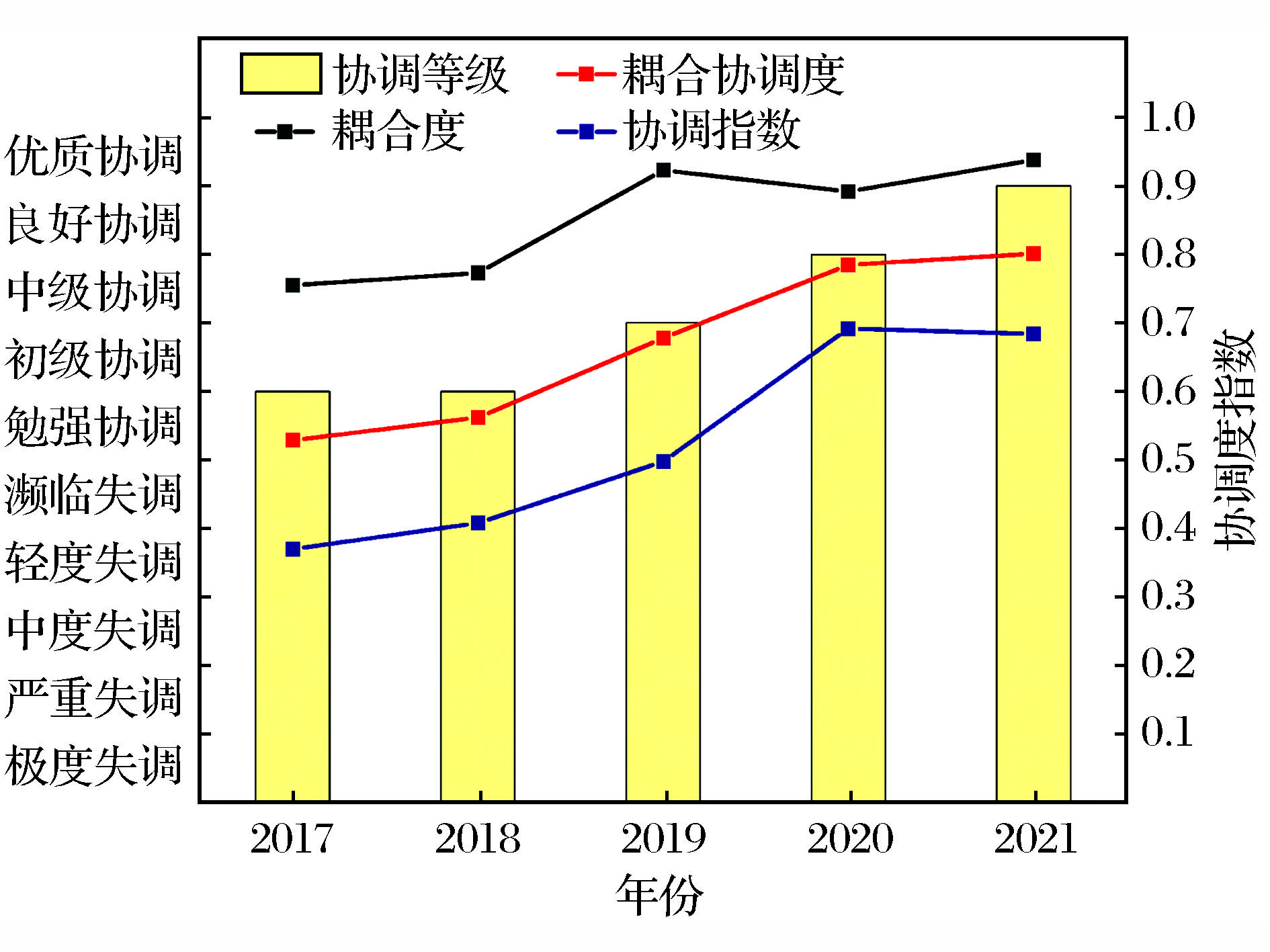
At present,the evaluation system and methods of green mine construction in the gold industry are not perfect.On the one hand,in most studies,when establishing the index system,the internal relations between indicators were ignored,and only the influencing factors related to green mine construction in general were listed.On the other hand,most of the models lack completeness when establishing the evaluation model, they only evaluate the construction results at a certain time point without showing the change trend of the construction process.Based on the framework model of driving forces,pressure,state,impact and response,the evaluation index system of green mines in gold industry was constructed to express the internal relationship between indicators more intuitively.In building the evaluation model,the subjective and objective combination weighting method was introduced so as to make the index weight meet the subjective expectations of the decision-makers and the objective judgment requirements of the inconsistency between the indicators.The TOPSIS coupling coordination model was introduced to quantitatively evaluate the space-time evolution process of green mine construction and the coupling coordination among subsystems,and the main obstacle factors affecting the green mine construction of enterprises were analyzed,providing guidance countermeasures for the improvement of green mine construction of enterprises.Through the analysis of an actual case of a gold mine in Shaanxi Province,it is concluded that the green mine construction of the general system of the mine and the coupling and coordination degree between the subsystems are steadily increasing,the construction of each subsystem is fluctuating.The industrial production capacity(C1),the energy consumption(C5),the mine environment(C9),and the mineral processing(C11) are the main obstacles in the construction process,which are consistent with the actual construction of the mine,and the applicability of the model is verified.The evaluation index system established in this paper clarifies the function mechanism of each index of green mine construction,which helps enterprises flexibly respond to a series of related factor changes caused by a certain index change.The established evaluation model improves the defect of subjective influence on the evaluation results in the traditional evaluation,highlights the internal connection and coordination between the evaluation indicators,makes the evaluation process and results more fair and reliable,and provides an effective way to promote the sustainable development of the gold industry mining industry.
Pakistan is rich in mineral resources and is one of China’s “all-weather strategic partners” and an important mining investment country.Based on the five risk levels of politics and law,economy and finance,resource extraction,social culture and infrastructure,this paper constructs a mining investment environmental risk evaluation index system in Pakistan from a dynamic perspective.The weight of indicators is determined by the improved CRITIC method,and the index information is collected by the TOPSIS method to explore the possible risk factors of Pakistan’s mining investment environment,so that the evaluation results are more accurate,scientific and referenceable.The deep learning model was used to predict the mining investment environment in Pakistan from 2023 to 2033,which provides a reference for the risk prevention of Pakistan’s mining investment environment in the future.The results show that:(1)Anti-globalization risk,resource abundance,social stability,environmental regulation,credit risk and corruption risk sink are the main influencing factors of Pakistan’s mining investment environment.(2)From 2000 to 2022,Pakistan’s mining investment environment score generally showes a spiraling trend,and the risk level was stable after being reduced to medium risk.In addition to the overall dynamic downward trend of infrastructure risk scores,the political and legal risks,economic and financial risks,social and cultural risks and resource exploitation risk scores all show a fluctuating upward trend.(3)From 2023 to 2033,Pakistan’s mining investment environment will be reduced from medium risk to low risk level,stable and improving.
Deep well large-scale mining is one of the important development trends of mining methods at home and abroad,but this mining method also faces the threat of complex ground pressure disasters.Based on the requirements for the design of microseismic monitoring system in Chambishi copper mine,a typical deep well large-scale distributed mining mine,the distributed microseismic monitoring system design scheme was studied in this paper.Deep well large-scale mining will inevitably lead to the dispersion of underground monitoring equipment.Because the microseismic data acquisition substations at different locations are running underground,due to the continuous accumulation of network delays,there will be large time synchronization errors,and the time synchronization errors will cause the microseismic events originally occurring in the south mining area to be located in the north mining area or in unrelated areas,so that the true location of ground pressure disasters cannot be accurately monitored.In addition,the microseismic monitoring software will carry out statistical analysis of all the monitored events when carrying out quantitative statistical analysis,and the ground pressure disaster activity characteristics in different regions have nonlinear characteristics,so it is necessary to carry out statistical analysis of data separately.In view of the difficulties in the design of distributed microseismic monitoring system,two key technologies have been researched and developed based on the existing microseismic monitoring system technologies.One is the high-precision time synchronization technology to solve the time synchronization problem of ultra long-distance distributed equipment,and the other is the monitoring data spatial filtering technology to solve the data analysis of ground pressure disaster activities in different regions.Based on the application of the above key technologies,the design concept of the distributed microseismic monitoring system was realized.At the same time,the network numerical calculation tool was used to simulate the system positioning accuracy of the distributed microseismic monitoring design scheme.The key data required by the microseismic monitoring network analysis tool are three-dimensional coordinate information of the sensor position,sensitivity value of the sensor,seismic wave velocity,P-wave variance and arrival error variance.Based on the above data,the positioning error was calculated numerically,and finally the three-dimensional cloud map of the positioning error in the central area and the surrounding area of the monitoring station network was obtained.The network analysis results show that the design scheme meets the monitoring needs of actual ground pressure activities,thus verifying the feasibility of the design scheme.The solution can be applied to the same type of mines and has certain promotion value.

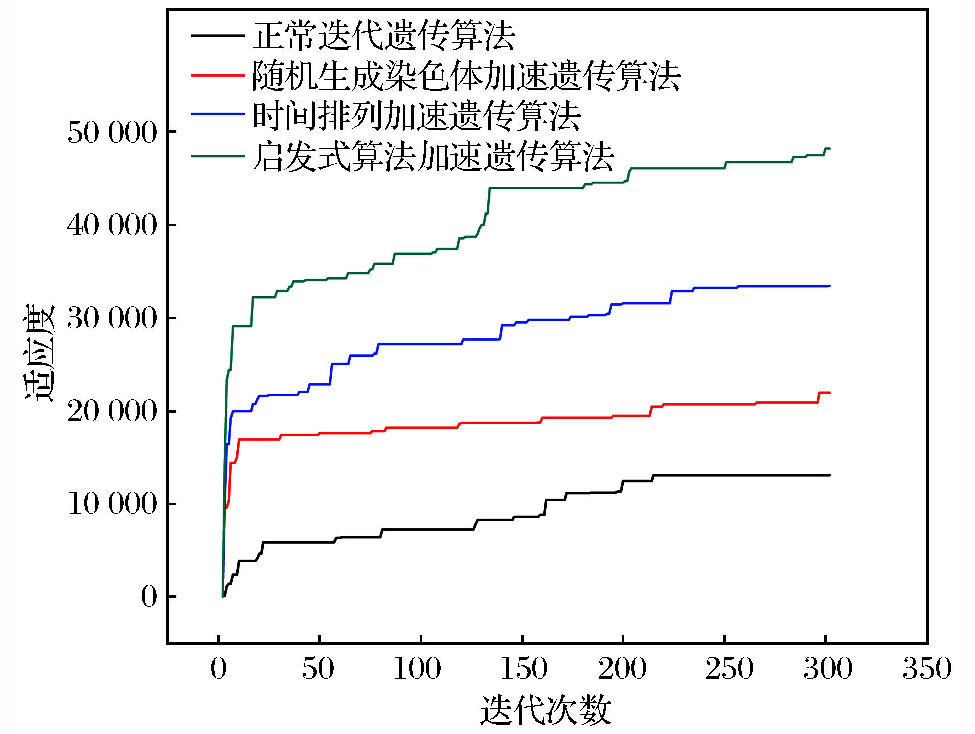
With the rapid development of digital economy in the world,how to realize the rapid optimal allocation of underground mine production equipment has become the key to the continuous advancement and in-depth application of digital mine.In view of the characteristics of underground mines such as limited space,limited equipment resources,and large production tasks,an optimization model was constructed for production planning of the follow-up filling mining method in the open pit using pre-controlled roof medium-and deep-hole and sublevel open-stopping and subsequent filling method.The model aims at minimizing the interval time between adjacent processes and the total production time,and the above issue is solved using genetic algorithms.The genetic algorithms used for solving the problem include traditional genetic algorithms and optimized genetic algorithms.Taking the actual data of a copper mine test stope in Zambia as an example,it can be seen from the iterative results that all genetic algorithms can solve the model,and the optimized genetic algorithm converges faster than the ordinary genetic algorithm.The genetic algorithm accelerated by heuristic algorithm has the fastest convergence speed.Therefore,the heuristic genetic algorithm is used to solve the multi-objective optimization model and the results are visualized.After analyzing the solution results,it is found that the average utilization rate of equipment is only 49.16%,and the utilization rate of some equipment is low,so the number of equipment is optimized.After the number of equipment was optimized and solved again,the average utilization rate of mine equipment increased to 64.8%,basically meeting the requirements of the mine.In terms of production,the daily average ore output is 3 631.19 t/d,which meets the mining demand and effectively shorts the operation time interval to ensure the requirements of mining safety.In addition,copper and cobalt sunrise ore grade fluctuation is small,easy to concentrate.Therefore,the algorithm and model can quickly and effectively solve the problem of multi-equipment coordination in a copper mine in Zambia,improve production efficiency and safe mining.
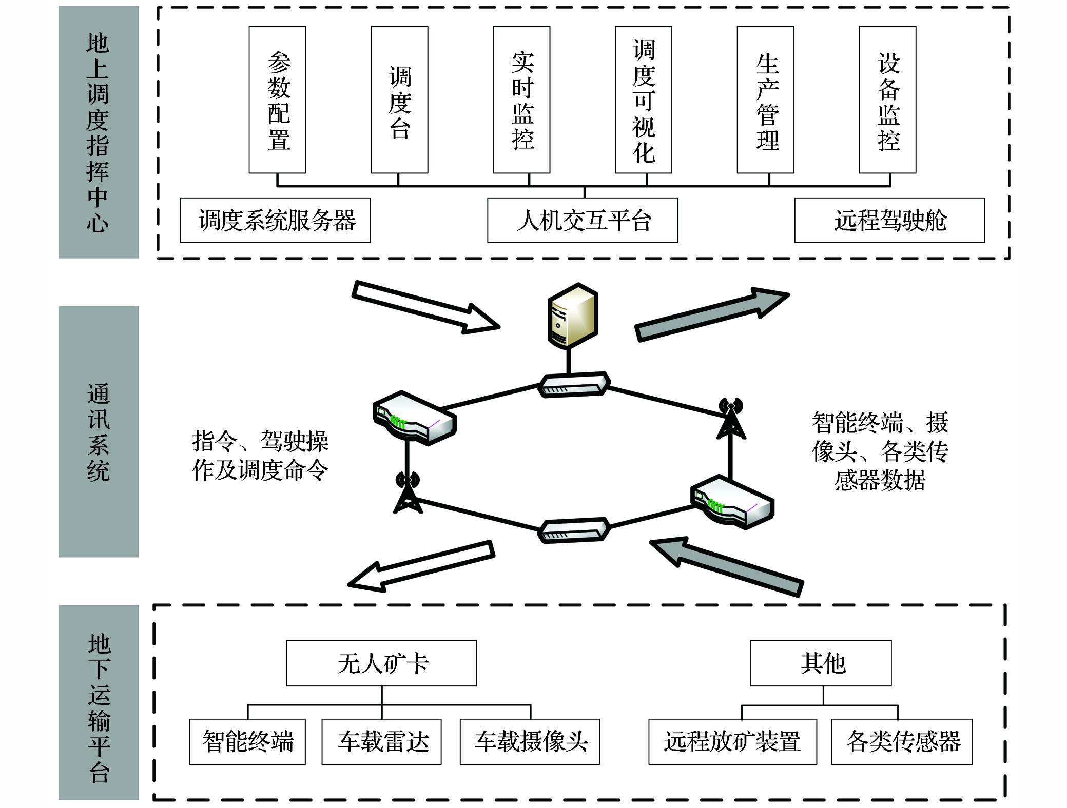
As a typical process industry,the mining of underground metal mines depends on the smooth operation of the ore transportation link,and the unmanned mine truck bears an indispensable and important responsibility in the ore transportation link,so the intelligent scheduling and management of the unmanned mine truck is the key to ensure the smooth production of the mine.There are few studies on the scheduling and management of unmanned mine trucks,and it is difficult to meet the new requirements brought by the increasing degree of unmanned mine trucks.Based on the analysis of the current situation of cluster intelligent scheduling strategy,scheduling business flow,and data integration system for unmanned mining trucks in a certain underground mine in Gansu province,an integrated system platform for intelligent decision-making,automatic scheduling,and process control serving unmanned mining trucks scheduling was proposed.In response to the transformation of unmanned mining trucks scheduling mode and two traffic control challenges,corresponding intelligent scheduling strategies were designed,and the overall architecture was designed.Some functional modules were designed,including scheduling console,real-time monitoring,scheduling visualization,and production management.The system platform has been successfully applied to the mine through the intelligent transformation of the mine truck,the construction of the intelligent dispatching system,and the development of the system.The application results show that the existing traffic control problems have been solved and the dispatching efficiency has been improved by 7.18% with the help of the intelligent dispatching system with the core of vehicle end scheduling algorithm,single-lane collision avoidance algorithm and merging truck algorithm.It provides a centralized and unified management and use platform for data,breaks the information island,and greatly improves the data utilization rate.Through vocational work split and process drive,the scheduling modular management is realized.The successful application of the platform has innovated the dispatching mode,supplemented the research in relevant fields,provides an important reference for the intelligent transformation of underground mines,and also provides reference experience for the development of cluster dispatching management system platform across equipment categories and production areas.
The raw ore of a carlin gold mine in Guizhou has low gold grade,fine disseminated granularity of valuable minerals and gangue minerals,and high content of harmful elements arsenic and carbon.The recovery rate of conventional fine grinding flotation process is only 80.54% and the gold grade of tailing is 0.97×10⁻⁶,the loss of flotation tailing gold is relatively serious.In order to improve the recovery rate of gold concentrate and reduce the gold grade of flotation tailing,the process mineralogy study of secondary grinding classification overflow and flotation tailing was carried out to find out the gold distribution and loss.The results show that the gold lost in conventional fine grinding flotation tailing is mainly sulfide wrapped gold,which is mainly lost in the poor coenobium of -38 μm grade,accounting for 60.70%,and the lost sulfide gold content is high.Secondly,there are a small amount of dissociated monomer and a small amount of fusant,which are not fully recovered due to the fine particle size,and also lost in the tailings.The main cause of the loss of gold in flotation tailing is that the fine particle minerals cannot be caught by conventional fine grinding flotation.Combined with the site production situation,the JRF micro-bubble flotation was applied to rough selection Ⅰ operation and scavenge Ⅳ tailing for reselection test.The test results show that JRF micro-bubble flotation has a significant catching effect on some fine particle minerals in tailing,which can further strengthen the capture of sulfide poor coenobium of -38 μm grade and a amount dissociation monomer of -20 μm grade in conventional fine grinding flotation scavenge Ⅳ tailing,and reduce the loss of gold in flotation tailing.After the technical transformation,the cumulative recovery rate of gold is 82.39% and the tailing grade is 0.88×10⁻⁶.The recovery rate increased by 1.85 percentage points,and the tailing grade decreased by 0.09×10⁻⁶,and the flotation index was gradually improved,which increased the economic benefits of enterprises.

In order to realize the comprehensive recovery of valuable metals in the cyanide circulating liquid,the comparative test and analysis of acidification and SART processes(Vulcanization-Acidification-Recycling-Concentration Process) was conducted,and the application of SART process was finally determined.Then the circulating liquid generated in the cyanide gold extraction process of the domestic gold industry was purified for the first time,and the step-by-step recovery and separation and precipitation of zinc and copper in the liquid phase of the cyanidation cycle were realized.47.45% zinc mud and 54.38% copper sludge were produced respectively,and recovered with high-grade precipitate products.And the weakly complexed cyanide is converted into free sodium cyanide and then returned to the production system for recycling,thereby reducing the cost of the cyanidation process.The application of SART process not only realizes the recovery of valuable metals,reduces the cost,but also solves the employment problem,reduces the pressure of subsequent smelting and environmental protection,and achieves good economic,environmental and social benefits.


 甘公网安备 62010202000672号