黄金科学技术 ›› 2024, Vol. 32 ›› Issue (1): 55-62.doi: 10.11872/j.issn.1005-2518.2024.01.066
常小鹏( ),张翔()
Xiaopeng CHANG(),Xiang ZHANG()
摘要:
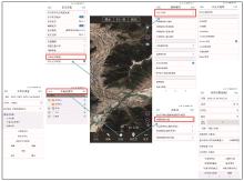
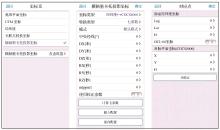
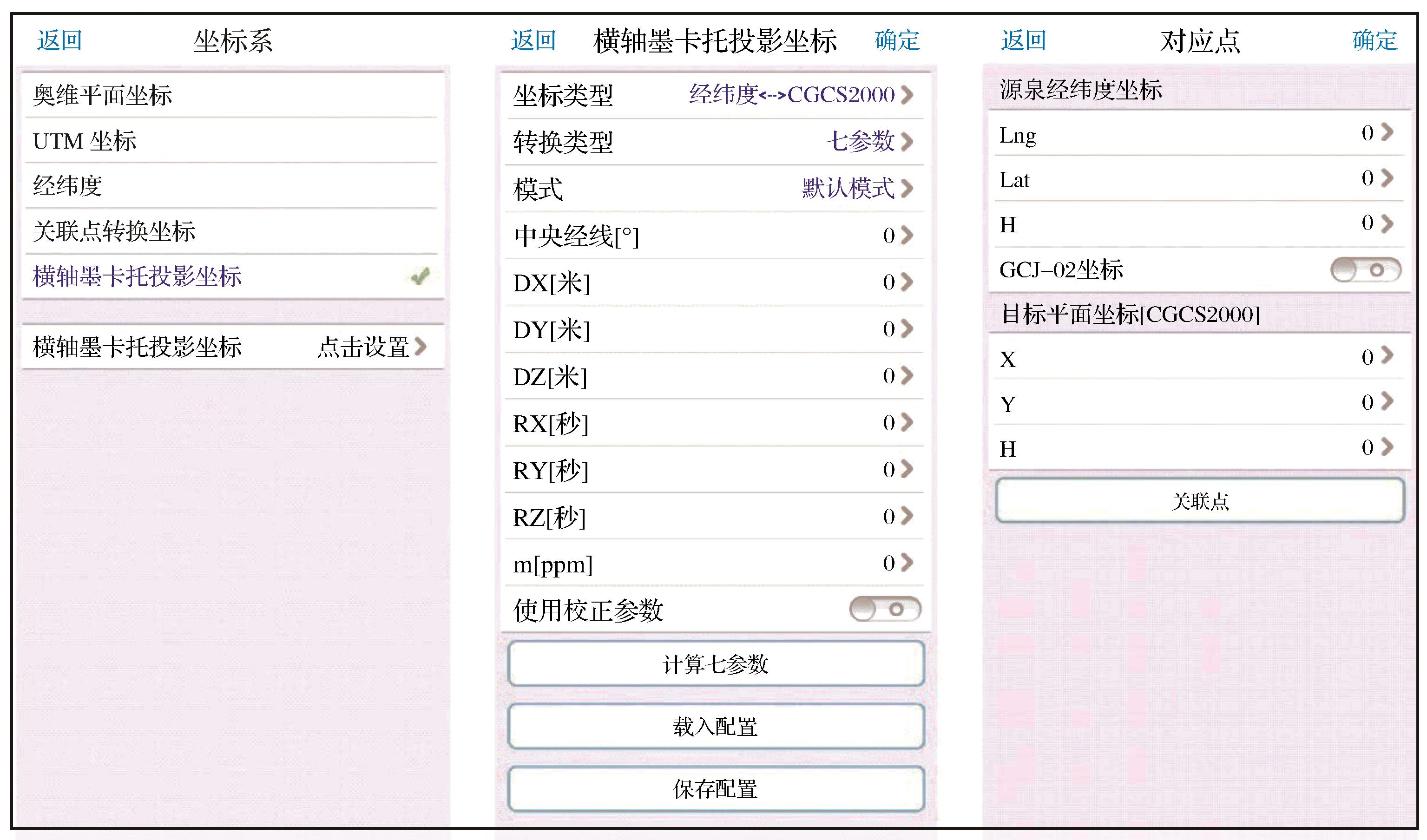
测线和测点布设是物探工作的重要内容,随项目运行不断变化更新。奥维互动地图的应用给测线、测点布设提供了极大便利。针对物探工作中地质图无法整合到APP,测线、测点布设效率不高等问题,以奥维互动地图基本操作为基础,介绍了利用水经微图下载图件导入奥维的应用方法,详细介绍了将收集地质图导入奥维并整合到APP的具体方法,有效实现了地质图在APP便携呈现,完善了测线、测点布设,提高了布设效率。结合在内蒙古及西藏地区开展的物探工作实例,补充说明了软件VIP共享功能的辅助作用。外业工作表明:合理发挥奥维地图软件的最大效能,探索新的软件使用方法对提高外业工作效率、加强数据管理具有重要意义。
中图分类号:
| Beijing Yuansheng Huawang Software Co.,Ltd.,2019.Introduction to Ovital map products[R].Beijing:Beijing Yuansheng Huawang Software Co.,Ltd. | |
| Chen Geng, Zhang Chunquan, Yang Fan,2021.Application of Ovi interactive map on basic surveying and mapping control point survey[J].Geomatics and Spatial Information Technology,44(10):181-183. | |
| Chen Zhifeng,2018.Application analysis of Ovital map in forestry production[J].South China Agriculture,12(15):92-94. | |
| Du Pengfei,2020.Application of Ovital map to seismic exploration[J].Chinese Journal of Engineering Geophysics,17(1):88-92. | |
| Gao Xingzhong, Ping Shubao,2021.Application of Orvey interactive map in forest resources management and conservation[J].Modern Agriculture Research,(12):103-105. | |
| Jia Jinke, Fang Faquan, Liu Yong,2016.Utilizing location services to realize field point finding and field demarcation[J].Geospatial Information,14(2):73-74. | |
| Li Haibin, Chen Tianqing,2018.Application of Ovital map in field survey of land improvement projects[J].Agriculture and Technology,38(16):246-247. | |
| Li Jinhui,2020.Application of Owei interactive map in seismic exploration of coal fields[J].North China Earthquake Sciences,38(Supp.1):24-28. | |
| Li Sijia, Xu Jingwu, Xu Hong,2020.Application of Ovital map software in engineering geological surveying and mapping[J].Architectural Engineering Technology and Design,(30):621-622. | |
| Lin Jizhao, Jia Dengke, Wu Jing,2014.Discussion and strategies about CGCS2000 and WGS84 coordinate system[J].Port and Waterway Engineering,(2):27-30. | |
| Ma Jiaqiong, Yang Xiaoying, Cui Wengang,et al,2013.The research of coordinate transformation between WGS-84 and Xi’an 80[J].Geomatics and Spatial Information Technology,36(4):158-160. | |
| Pan Lili, Wu Jiaobing, Li Xiguang,2020.Application of Ovital map in urban geological survey and exploration[J].Guizhou Geology,37(1):103-109. | |
| Pang Huasi,2022.Application of Ovital interactive map in oil shale exploration in Maoming City[J].Science and Technology Information,11(22):61-64. | |
| Peng Xiaoqiang, Gao Jingxiang, Wang Jian,2015.Research of the coordinate conversion between WGS84 and CGCS2000[J].Journal of Geodesy and Geodynamics,35(2):219-221. | |
| Peng Zhen, Tu Xiaofang,2020.Application of Ovital map in geological survey[J].Urban Geology,15(2):228-232. | |
| Tan Daobiao,2020.Application of Oville interactive map in forestry work[J].Forest Inventory and Planning,45(3):14-16. | |
| Tao Chuan, Liang Chao,2021.Application of Ovital map in site selection of temporary construction facilities of expressways[J].Sichuan Building Materials,47(11):119-120. | |
| Wang Jiangyu, Wu Sha, Zhang Zhiyu,et al,2016.Research and application of Ovital map mobile terminal on site survey and route selection technology[J].Petrochemical Industry Technology,(6):115-116. | |
| Wang Zhihong, Yin Zhan, Zhang Jianguo,et al,2020.Application of Ovitalmap in the itinerary planning of field geological survey[J].Mineral Exploration,11(5):959-963. | |
| Wei Fan,2020.Application research of Ovital map in field survey of highway design[J].Design of Hydroelectric Power Station,36(1):14-18. | |
| Wu Jianguang,2017.Design of overhead transmission line selection based on Ovital map[J].Mechanical and Electrical Information,(15):128-129. | |
| Wu Yan, Yang Zhiheng, Wang Chao,et al,2021.Application of Ovital map in planning and design project investigation:Taking a mine ecological restoration design project as an example[J].Soil and Water Conservation in China,(5):58-60. | |
| Xu Qinghua, Mu Yongbao, Du Peng,et al,2017.Application of Ove intractive map in transmission line survey and design[J].Journal of Shanghai Electric Technology,10(3):30-32. | |
| Yang Fan,2021.Application of Omap in risk assessment of geological hazard in power transmission project[J].Yunnan Water Power,37(11):51-53. | |
| Yang Liu, Guo Jian, Wang Jungang,et al,2021.Application of Ovital map in engineering construction[J].Sichuan Building Materials,47(4):89-91. | |
| Yin Chengbao,2021.Application of Ovital map KML file in various stages of water conservancy engineering survey[J].Harnessing the Huaihe River,(8):25-26. | |
| Zhang Yanyan, Deng Zhongjian, Dang Xuliang,et al,2021.Application of Ovital map in wind farm operation and maintenance work[J].Henan Electric Power,(Supp.):80-82. | |
| Zhou Jingquan,2019.The application of the Ovi interactive map to the earlier survey for the construction of railway projects[J].Traffic Engineering and Technology for National Defence,17(4):70-73. | |
| Zhu Benyu, Liu Dan, Lu Xiuxue,et al,2021.Application of Ovital map in transmission line engineering[J].Electric Power,(2):32-34. | |
| 北京元生华网软件有限公司,2019.奥维互动地图产品介绍[R].北京:北京元生华网软件有限公司. | |
| 陈庚,张春泉,杨帆,2021.奥维互动地图在基础测绘控制点普查中的应用[J].测绘与空间地理信息,44(10):181-183. | |
| 陈志峰,2018.奥维互动地图在林业生产中的应用分析[J].南方农业,12(15):92-94. | |
| 杜鹏飞,2020.奥维互动地图在地震勘探中的应用[J].工程地球物理学报,17(1):88-92. | |
| 高兴忠,平树宝,2021.奥维互动地图在森林资源管护中的运用探索[J].现代农业研究,(12):103-105. | |
| 贾进科,方发全,刘勇,2016.利用位置服务实现野外找点与实地指界[J].地理空间信息,14(2):73-74. | |
| 李海斌,陈田庆,2018.奥维地图在土地整治项目野外踏勘中的应用[J].农业与技术,38(16):246-247. | |
| 李金辉,2020.奥维互动地图在煤田地震勘探中的应用[J].华北地震科学,38(增1):24-28. | |
| 李思嘉,徐敬武,徐虹,2020.奥维地图软件在工程地质测绘中的应用[J].建筑工程技术与设计,(30):621-622. | |
| 林吉兆,贾登科,武警,2014.CGCS2000及WGS84坐标系若干问题探讨及应对策略[J].水运工程,(2):27-30. | |
| 马家琼,杨晓英,崔文刚,等,2013.WGS-84与西安80坐标转换研究[J].测绘与空间地理信息,36(4):158-160. | |
| 潘黎黎,吴教兵,李细光,2020.奥维互动地图在城市地质调查勘测中的应用[J].贵州地质,37(1):103-109. | |
| 庞华思,2022.奥维互动地图在茂名市油页岩勘查中的应用探索[J].科技资讯,11(22):61-64. | |
| 彭小强,高井祥,王坚,2015.WGS84和CGCS2000坐标转换研究[J].大地测量与地球动力学,35(2):219-221. | |
| 彭振,涂晓方,2020.奥维地图在野外地质调查工作中的应用[J].城市地质,15(2):228-232. | |
| 覃道彪,2020.奥维互动地图在林业工作中的应用探析[J].林业调查规划,45(3):14-16. | |
| 陶川,梁超,2021.奥维地图在高速公路临建设施选址上的运用[J].四川建材,47(11):119-120. | |
| 王江宇,吴沙,张智禹,等,2016.奥维地图移动终端踏勘选线技术的研究与应用[J].石化技术,(6):115-116. | |
| 王志红,尹展,张建国,等,2020.奥维软件在野外地质调查行程规划中的应用[J].矿产勘查,11(5):959-963. | |
| 魏翻,2020.奥维地图在公路设计外业踏勘中的应用研究[J].水电站设计,36(1):14-18. | |
| 巫剑光,2017.基于奥维互动地图的架空输电线路选线设计[J].机电信息,(15):128-129. | |
| 吴焱,杨之恒,王超,等,2021.奥维互动地图在规划设计项目调查中的应用:以某矿山生态修复设计项目为例[J].中国水土保持,(5):58-60. | |
| 徐庆华,穆永保,杜鹏,等,2017.奥维互动地图在输电线路勘察设计中的应用[J].上海电气技术,10(3):30-32. | |
| 杨帆,2021.奥维地图在输变电工程地质灾害危险性评估中的应用[J].云南水利发电,37(11):51-53. | |
| 杨柳,郭剑,王军刚,等,2021.奥维互动地图在工程施工中的应用[J].四川建材,47(4):89-91. | |
| 尹成宝,2021.奥维地图KML文件在水利工程测绘各阶段中的应用[J].治淮,(8):25-26. | |
| 张焱焱,邓忠建,党旭亮,等,2021.奥维互动地图在风电场运维工作中的应用[J].河南电力,(增):80-82. | |
| 周京全,2019.奥维互动地图在铁路项目施工初期测量中的应用[J].国防交通工程与技术,17(4):70-73. | |
| 朱本玉,刘丹,鲁修学,等,2021.奥维互动地图在输电线路工程中的应用[J].电网技术,(2):32-34. |
| [1] | 秦运忠, 宋海军. 广西乐业县岩旦—岩堂金矿床找矿模型及成矿预测[J]. 黄金科学技术, 2020, 28(3): 317-327. |
| [2] | 康恩胜, 孟海东, 赵自豪, 何滔. 基于物探技术的露天矿边坡失稳因素勘测研究[J]. 黄金科学技术, 2020, 28(3): 363-371. |
| [3] | 刘诗鹏,王树亚,冯欣欣,殷传印. 胶东三山岛西岭金矿区NW向断裂带的确定:综合物探证据[J]. 黄金科学技术, 2019, 27(1): 25-32. |
| [4] | 李永生,孙焕英,夏国彬,卢倩. 区域地质图图例系统库调用方法与应用研究[J]. 黄金科学技术, 2015, 23(5): 83-87. |
| [5] | 郑振云,刘召军,郑洁. CSAMT法在甘肃寨上金矿区南矿带找矿中的应用[J]. 黄金科学技术, 2014, 22(2): 13-16. |
| [6] | 张玉杰,张文华,史晓翠,路彦明. MapGIS制图中随意参数底图的矢量校正[J]. 黄金科学技术, 2013, 21(4): 83-86. |
| [7] | 王元魁,王振军,刘福江. 物探新技术在三山岛金矿探水中的应用[J]. 黄金科学技术, 2013, 21(1): 58-61. |
| [8] | 徐春宏,蒋鑫. 综合物探方法在内蒙古草原覆盖区寻找隐伏矿床的应用[J]. J4, 2011, 19(4): 13-18. |
| [9] | 张艳梅,刘喜友. 综合物探法在黑龙江老柞山金矿接替资源勘查中的应用[J]. J4, 2011, 19(2): 61-66. |
| [10] | 林正泽, 卓奉吉, 刘伟, 张艳梅. 物探在白岭铜锌矿床勘探中的应用效果[J]. J4, 2009, 17(2): 42-45. |
| [11] | 狄卫民. 地质剖面图和平面图的计算机辅助绘制[J]. J4, 2002, 10(4): 36-39. |
|
||
©2018 黄金科学技术编辑部
电话:0931-8277791
E-mail: hjkx@lzb.ac.cn 邮编:730000


 甘公网安备 62010202000672号