img

Wechat

Adv. Search

Gold Science and Technology ›› 2023, Vol. 31 ›› Issue (5): 773-784.doi: 10.11872/j.issn.1005-2518.2023.05.082

• Mining Technology and Mine Management • Previous Articles     Next Articles

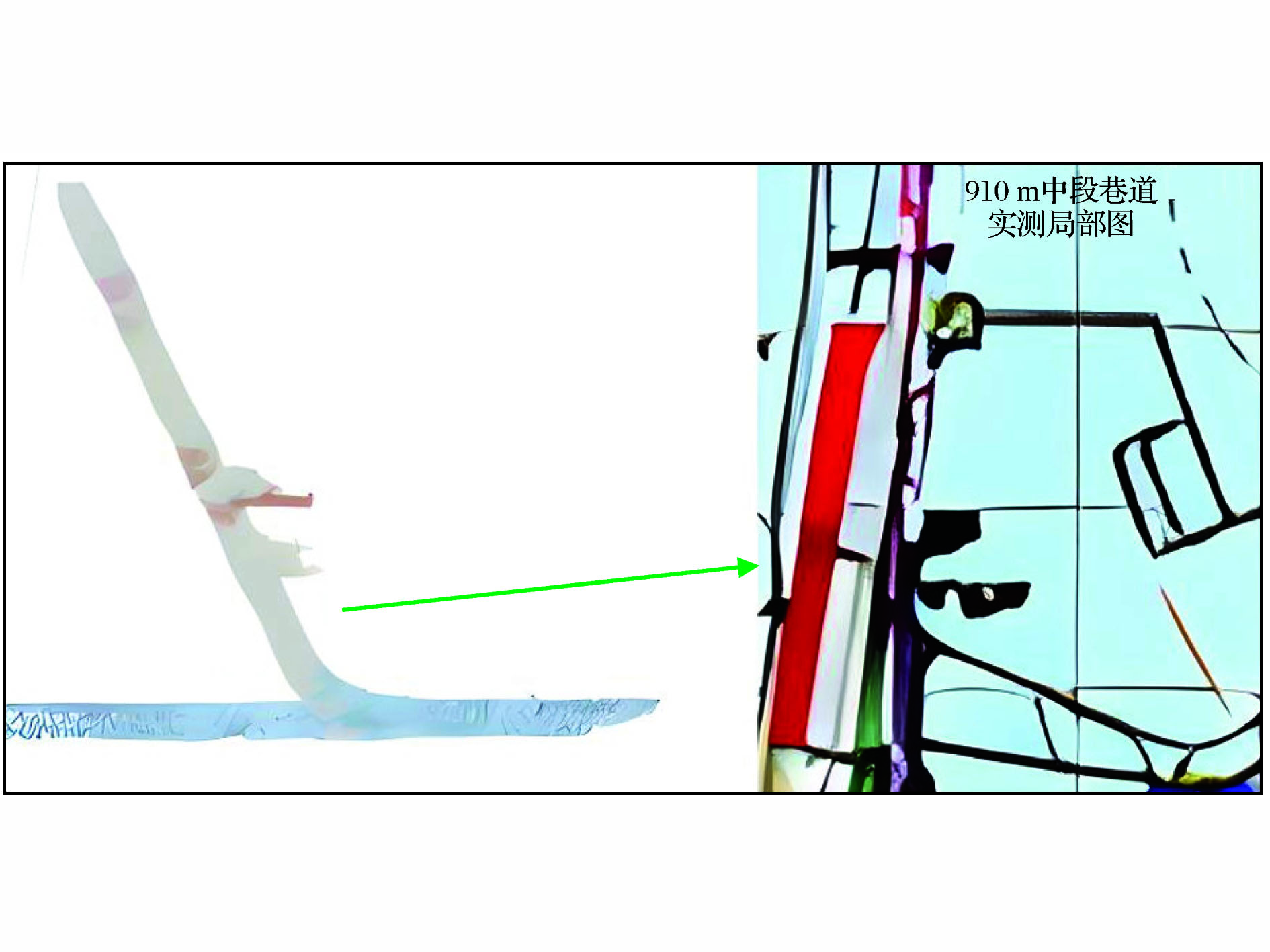
Research on “Manual+Semi-automatic” Identification Method and Application of Roadway Rock Mass Structural Plane

Xiaoming ZHAO1,2(),Xiang LI3,Jielin LI3(),Tongfei YANG1,2,Jiachen ZHENG1,2,Bo YANG4,Changjun LI4   

  1. 1.North China Non-Ferrous Engineering Survey Institute Co. , Ltd. , Shijiazhuang 050000, Hebei, China
    2.Innovation Center of Metal Mine Groundwater Disaster Prevention Engineering Technology, Ministry of Natural Resources, Shijiazhuang 050000, Hebei, China
    3.School of Resources and Safety Engineering, Central South University, Changsha 410083, Hunan, China
    4.Tianhe Daoyun (Beijing) Technology Co. , Ltd. , Beijing 100176, China
  • Received:2023-05-31 Revised:2023-07-23 Online:2023-10-31 Published:2023-11-21
  • Contact: Jielin LI E-mail:707473672@qq.com;lijielin@163.com

Abstract:

Roadway is the main engineering for the development,production and transportation of underground metal mines.The stability of surrounding rock of underground roadway will directly affect the safety production of the mine.The structural analysis of roadway rock mass was carried out to obtain the spatial characteristics of the surrounding rock structural plane,so as to analyze the characteristics and instability of blocks cutted by structural plane,and identify the dangerous area of roadway block instability,so as to provide a good guarantee for roadway safety.The information acquisition of rock mass structural plane includes the measurement of occurrence,trace length,spacing and opening degree.At present,there are mainly full manual identification,semi-manual identification and automatic identification methods to carry out rock mass structural plane identification.Different methods have different effects on the identification accuracy of rock mass structural plane,but it is generally difficult to accurately distinguish the surrounding rock defects and structural plane of underground roadways,and the accuracy of the identified structural plane data is poor.Therefore,it is very necessary to develop a safe and accurate rock mass structural plane measurement and identification technology to provide accurate data support for the accurate deconstruction and stability analysis of roadway structural plane.In order to strengthen the high quality and high precision identification and optimization of the structural point cloud data of the surrounding rock of underground roadway,the research on the measurement and identification of the structural plane of underground roadway rock mass was carried out based on 3D laser scanning technology.In this paper,the structural plane identification method based on point cloud data was summarized,and three-dimensional laser scanning and structural plane information extraction were carried out in the 910 m midsection transportation roadway of Maoping lead-zinc mine,Luozehe Town,Yilang County,Yunnan Province.Finally,the field manual measurement and manual identification,semi-automatic identifi-cation and manual identification were compared and verified and analyzed.The results show that in the underground mine roadway,when the combination of manual identification and semi-automatic identification was used to identify the rock mass structural plane of the roadway,the obtained structural plane data is more accurate and comprehensive.Due to the advantages of high precision and convenience of 3D laser scanning,the combination of “manual+semi-automatic”identification method has great further optimization in the measurement and identification of rock mass structural plane of underground roadway.It provides a new idea for the identification of tunnel structural plane information and the extraction of geometric features,and provides an efficient and accurate measurement method for the identification of tunnel structural plane.

Key words: underground roadway, structural plane identification, three-dimensional laser scanning, point cloud data, structural plane measurement

CLC Number: 

  • P585.2

Fig.1

Selection of measurement area"

Fig.2

Erection of measuring station"

Fig.3

Roadway point cloud data model"

Fig.4

Coordinate matching of point cloud data"

Fig.5

Comparison of structural plane characteristics between measured photos of surrounding rock and point cloud data scanning"

Fig.6

Comparative verification of structural plane characteristics identification"

Fig.7

Fitting verification of structural plane"

Table 1

Error of manually selected structural plane identification and traditional compass measurement results"

测量点平均倾向/(°)平均倾角/(°)平均差值
罗盘测量5366-
测量点14177倾向12°,倾角11°
测量点22080倾向23°,倾角14°
测量点32977倾向24°,倾角11°
测量点45570倾向2°,倾角4°

Fig.8

Structural plane occurrence division of point cloud data"

Fig.9

Division of the study area"

Fig.10

Division of roadway area"

Fig.11

Identification results of rock mass structural plane"

Fig.12

Identification area of rock mass structural plane"

Table 2

Identification results of structural plane"

序号距离/m倾角/(°)倾向/(°)长度/m
10.50248.71045.3230.463
20.53050.78862.6010.689
30.65750.521257.7350.524
40.80572.196229.4410.700
51.18847.16385.7220.511
61.43170.671318.6300.610
71.80767.868327.1530.438
81.85860.332330.4440.766
93.12776.597208.3830.846
103.20471.638214.9920.904
113.70577.771318.7120.857
124.42075.932331.1851.244
134.72462.339311.7660.953
145.36156.631247.1640.348
155.45754.570269.0420.247
166.63165.778272.3700.439
177.26984.909344.5670.408
187.41779.184325.2980.432
197.55653.99656.02700.415
208.08058.446294.7480.975
219.00370.242314.9580.638
229.86651.262281.4700.493
239.99569.971318.3910.641
2410.45761.27344.0880.599
2510.60259.355283.2600.371
2611.02380.960331.7340.469
2711.36060.214281.4440.748
2811.57571.872329.6680.554

Fig.13

Identification results of rock mass structural plane identification region"

Fig.14

Identification results of structural plane of rock mass in different regions"

Fig.15

Occurrence of structural plane"

An P J, Kun F, Jiang Q Q,et al,2021.Measurement of rock joint surfaces by using smartphone structure from motion(SfM)photogrammetry[J].Sensors,56(1):167-189.
Chen Na,2018.Study on Structure Information Extraction and Deformation Monitoring of Slope Rock Mass Based on Three-Dimensional Laser Scanning [D].Wuhan:Wuhan University.
Chen S, Walske M, Davies I,2018.Rapid mapping and analysing rock mass discontinuities with 3D terrestrial laser scanning in the underground excavation[J].International Journal of Mining Science and Technology,110(3):28-35.
Dong Xiujun, Huang Runqiu,2006.Application of 3D laser scanning technology in geological survey of high and steep slope [J].Chinese Journal of Rock Mechanics and Engineering,25(Supp.2):3629-3635.
Ge Yunfeng, Xia Ding, Tang Huiming,et al,2017.Intelligent identification and information extraction of rock mass disjoint based on three-dimensional laser scanning technology [J].Chinese Journal of Rock Mechanics and Engineering,36(12):3050-3061.
Guo Dengshang, Xie Mowen, Liu Weinan,et al,2022.Extraction method and application of slope rock mass structural plane based on three-dimensional point cloud [J].Mining Research and Development,42(5):197-202.
He Bingshun, Ding Liuqian, Sun Ping,et al,2007.Application of three-dimensional laser scanning system in rock mass discontinuance identification [J].Journal of China Institute of Water Resources and Hydropower Research,5(1):45-47.
He Fulian, Zhang Guangchao,2015.Analysis and control of stability of the fractured soft rock surrounding a deep roadway[J].Rock and Soil Mechanics,36(5):1397-1406.
Hou Chaojiong, Wang Xiangyu, Bai Jianbiao,et al,2021.Basic theory and technology study of stability control for surrounding rock in deep roadway[J].Journal of China University of Mining and Technology,50(1):1-12.
Hu Wuting, Liu Chang, Dong Xiujun,et al,2023.Automatic identification method of rock slope structural surface based on 3D laser scanning [J].Journal of Chengdu University of Technology (Science & Technology Edition),50(3):351-360.
Jing Hongdi, Li Yuanhui, Zhang Zhong,et al,2015.Extraction of rock mass structural plane information based on three-dimensional laser scanning [J].Journal of Northeastern University (Natural Science Edition),36(2):280-283.
Kong D, Sarogloub C, Wu F,et al,2021.Development and application of UAV-SfM photogrammetry for quantitative characterization of rock mass discontinuities[J].Internati-onal Journal of Rock Mechanics and Mining Sciences,141(1):23-45.
Li H, Li X, Li W,et al,2019.Quantitative assessment for the rockfall hazard in a post-earthquake high rock slope using terrestrial laser scanning[J].Engineering Geology,248(2):1-9.
Li Jielin, Bai Dewei, Yang Chengye,et al,2022.Recognition and stability analysis of underground tunnel rock mass structural plane based on 3D laser scanning point cloud data[J].Gold Science and Technology,30(3):343-351.
Li Jielin, Yang Chengye, Hu Yuan,et al,2020.Application of UAV 3D laser scanning technology in underground goaf detection [J].Metal Mine,49(12):168-172.
Li Jielin, Yang Chengye, Peng Zhaozhi,et al,2021.Application of three-dimensional laser scanning technology in identification of structural plane of underground roadway rock mass [J].Gold Science and Technology,29(2):236-244.
Li Pengyu, Jiang Yue, Zong Qi,et al,2018.Measurement and calculation of stope volume of a gold mine based on three-dimensional laser scanning technology [J].Metal Mine,47(4):145-149.
Li Zebang,2018.Research on Application of Three-Dimensional Laser Scanning Technology in Mine Goaf Slope Deformation Monitoring[D].Kunming:Kunming University of Science and Technology.
Liang Yufei, Pei Xiangjun, Cui Shenghua,et al,2021.Structural characteristics of rock mass at landslide failure boundary based on ground three-dimensional laser point cloud[J].Chinese Journal of Rock Mechanics and Engineering,40(6):1209-1225.
Qiu Junling, Xia Qinglin, Yao Lingqing,et al,2012.Mine geological modeling and application based on three-dimensional laser scanning technology[J].Earth Science,37(6):1209-1216.
Xu Du, Feng Xiating, Li Shaojun,et al,2018.Technology and application of laser scanning to test tunnel deformation and rock mass discontinuity[J].Chinese Journal of Geotechnical Engineering,40(7):1337-1342.
陈娜,2018.基于三维激光扫描的边坡岩体结构信息提取和变形监测研究[D].武汉:武汉大学.
董秀军,黄润秋,2006.三维激光扫描技术在高陡边坡地质调查中的应用[J].岩石力学与工程学报,25(增2):3629-3635.
葛云峰,夏丁,唐辉明,等,2017.基于三维激光扫描技术的岩体结构面智能识别与信息提取[J].岩石力学与工程学报,36(12):3050-3061.
郭登上,谢谟文,刘卫南,等,2022.基于三维点云的边坡岩体结构面提取方法与应用[J].矿业研究与开发,42(5):197-202.
何秉顺,丁留谦,孙平,等,2007.三维激光扫描系统在岩体结构面识别中的应用[J].中国水利水电科学研究院学报,5(1):45-47.
何富连,张广超,2015.深部破碎软岩巷道围岩稳定性分析及控制[J].岩土力学,36(5):1397-1406.
侯朝炯,王襄禹,柏建彪,等,2021.深部巷道围岩稳定性控制的基本理论与技术研究[J].中国矿业大学学报,50(1):1-12.
胡武婷,刘昶,董秀军,等,2023.基于三维激光扫描的岩质边坡结构面自动识别方法[J].成都理工大学学报(自然科学版),50(3):351-360.
荆洪迪,李元辉,张忠,等,2015.基于三维激光扫描的岩体结构面信息提取[J].东北大学学报(自然科学版),36(2):280-283.
李杰林,白德威,杨承业,等,2022.基于三维激光扫描点云数据的地下巷道岩体结构面识别及稳定性分析[J].黄金科学技术,30(3):343-351.
李杰林,杨承业,胡远,等,2020.无人机三维激光扫描技术在地下采空区探测中的应用研究[J].金属矿山,49(12):168-172.
李杰林,杨承业,彭朝智,等,2021.三维激光扫描技术在地下巷道岩体结构面识别的应用[J].黄金科学技术,29(2):236-244.
李鹏宇,姜岳,宗琪,等,2018.基于三维激光扫描技术的某金矿采场体积测量与计算[J].金属矿山,47(4):145-149.
李泽邦,2018.基于三维激光扫描技术在矿山采空区边坡变形监测中的应用研究[D].昆明:昆明理工大学.
梁玉飞,裴向军,崔圣华,等,2021.基于地面三维激光点云的滑坡破坏边界岩体结构特征分析[J].岩石力学与工程学报,40(6):1209-1225.
邱俊玲,夏庆霖,姚凌青,等,2012.基于三维激光扫描技术的矿山地质建模与应用[J].地球科学,37(6):1209-1216.
许度,冯夏庭,李邵军,等,2018.激光扫描隧洞变形与岩体结构面测试技术及应用[J].岩土工程学报,40(7):1337-1342.
[1] Hao ZHANG,Li QING,Shili QIU,Yongyuan KOU,Yunlin GUO,Shengyan XIA. Application of Three-dimensional Laser Scanning in Extracting Rock Mass Structure Information of Tunnel [J]. Gold Science and Technology, 2023, 31(2): 313-322.
[2] Jielin LI,Chengye YANG,Chaozhi PENG,Keping ZHOU,Ruikai LIU. Application of 3D Laser Scanning Technology to Identification of Rock Mass Structural Plane in Roadway of Underground Mine [J]. Gold Science and Technology, 2021, 29(2): 236-244.
Viewed
Full text


Abstract

Cited

  Shared   
  Discussed   
No Suggested Reading articles found!