img

Wechat

Adv. Search

Gold Science and Technology ›› 2020, Vol. 28 ›› Issue (1): 105-111.doi: 10.11872/j.issn.1005-2518.2020.01.043

• Mining Technology and Mine Management • Previous Articles     Next Articles

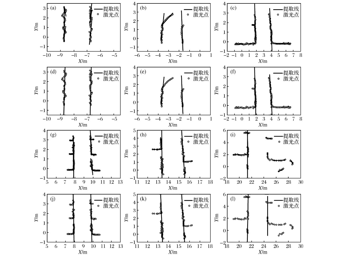
Roadway Edge Detection Algorithm Based on RANSAC in Underground Mine

Lin BI1,2(),Changming DUAN1,2(),Zhuli REN1,2   

  1. 1.School of Resources and Safety Engineering,Central South University,Changsha 410083,Hunan,China
    2.Center of Digital Mine Research,Central South University,Changsha 410083,Hunan,China
  • Received:2019-05-05 Revised:2019-09-17 Online:2020-02-29 Published:2020-02-26
  • Contact: Changming DUAN E-mail:Mr.BiLin@163.com;Changming_duan@163.com

Abstract:

Because the working environment of underground LHD(load-haul-and-dump-machine)is very bad,and with the increase of mining depth in underground mines,the realization of underground unmanned LHD is of great significance for ensuring the safety and health of workers and improving the production efficiency of mining enterprises.Navigation and positioning of LHD is one of the difficulties in the research of unmanned LHD.At present,the navigation technology of underground LHD mainly includes plan-based metric navigation and reactive navigation.The reactive navigation technology has the advantages of low cost and low computation.The former reactive navigation technology mainly relies on adding beacons manually,it has the shortcomings of high cost and poor adaptability.The roadway edge is an important natural beacon perception information,which has natural advantages compared with the artificial beacon.Foreign scholars had applied it to the reactive navigation system of underground LHD and achieved good navigation effect.However,they only did the research on the detection of the roadway edge in the straight roadway,no further discussion on the detection of roadway edge in more complex underground environments.Therefore,a more applicable roadway edge detection algorithm is proposed in this paper.This method is based on two-dimensional laser scanning information and random sampling consistency (RANSAC).The flow chart of the algorithm is as follows:Firstly,the curvature of each laser point in the laser point cloud is calculated,according to the curvature threshold,the laser point cloud data are divided into several regions.RANSAC algorithm is used to extract the roadway edges from each region.Then,the roadway edges are filtered according to the heading angle of the LHD and the design criteria of the roadway.Lastly,the laser point cloud data contained in the remaining roadway edges is merged,and the final roadway edges is generated by RANSAC algorithm again.This article simulated the laser data of six underground mine roadway scenarios,and these six sets of data included typical scenes from simple to complex in underground mine.The experiment was based on MATLAB,and the experimental results were analyzed from the aspects of parallelism,proportion of interior points,fit degree with heading angle,visual display and so on.The calculated results show that the reliability of the extracted roadway edges is more than 96%,and the visual results are in line with the actual situation.This method can detect roadway edge in various scenarios of underground mines,and has high robustness,the roadway edge detection algorithm can play an important technical support role in the reactive navigation of underground LHD,and is of great significance to the realization of the unmanned underground LHD.

Key words: underground LHD, lidar, random sampling consistency, roadway edge detection, reactive navigation, underground mine

CLC Number: 

  • TD525

Fig.1

Roadway edge detection process based on RANSAC"

Fig.2

Laser point cloud data set"

Fig.3

Effect map of roadway edge extraction"

Table 1

Reliability analysis of roadway edge(%)"

数据集序号平行度与航向角契合度内点占比总体可靠度
平均值97.4598.3496.1697.32
(a)99.4399.2394.5097.72
(b)93.0197.78100.0096.93
(c)97.7296.7495.3196.59
(d)97.3399.2294.9097.15
(e)98.7197.7992.2596.25
(f)98.5199.31100.0099.27

Table 2

Operating time of algorithm"

数据集序号解算时间/ms
平均值72.51
(a)68.46
(b)53.74
(c)76.74
(d)89.47
(e)64.51
(f)82.12

Table 3

Reliability of roadway edge extracted from different angle resolution data"

数据集序号巷道边线可靠度/%
1×角度2×角度3×角度
(a)97.7297.7796.39
(b)96.9392.5093.05
(c)96.5997.3795.74
(d)97.1599.1497.11
(e)96.2595.1796.06
(f)99.2791.2393.85

Table 4

Variance analysis of experimental date"

方差来源平方和自由度均方F
总和69.05517
数据角度分辨率11.72325.8621.579
不同井下场景20.19854.0401.088
随机误差37.134103.713
1 Dragt B J.Modeling and Control of an Autonomous Underground Vehicle[D].Pretoria:University of Pretoria,2006.
2 陈盟,王李管,贾明涛,等.地下铲运机自主导航研究现状及发展趋势[J].中国安全科学学报,2013,23(3):130-134.
Chen Meng,Wang Liguan,Jia Mingtao,et al.An overview of autonomous navigation techniques and development trend for underground LHD[J].China Safety Science Journal,2013,23(3):130-134.
3 姜勇.基于双变量PID控制算法的地下智能铲运机自主导航技术研究[J].机械制造,2016,54(5):19-22.
Jiang Yong.Technical study on autonomous navigation of smart underground scraper based on bivariate PID control algorithm[J].Machinery,2016,54(5):19-22.
4 杨超,陈树新,刘立,等.反应式导航在地下自主行驶铲运机中的应用[J].煤炭学报,2011,36(11):1943-1948.
Yang Chao,Chen Shuxin,Liu Li,et al.Reactive navigation for underground autonomous scraper[J].Journal of China Coal Society,2011,36(11):1943-1948.
5 Larsson J.Reactive Navigation of an Autonomous Vehicle in Underground Mines[D].Orebro:Orebro University,2007.
6 Borenstein J,Everett H R,Feng L,et al.Mobile robot positioning:Sensors and techniques[J].Journal of Robotic Systems,1997,14(4):231-249.
7 李晓梅,贾明涛,李宁,等.基于模糊控制的井下自主铲运机的安全导航[J].矿冶工程,2013,33(4):22-26.
Li Xiaomei,Jia Mingtao,Li Ning,et al.Safe navigation of underground autonomous carry scraper based on fuzzy control[J].Mining and Metallurgical Engineering,2013,33(4):22-26.
8 张绍光.基于局部重建的点云特征点提取[D].大连:大连理工大学,2013.
Zhang Shaoguang.Feature Detection on Point Clouds Via Local Reconstruction[D].Dalian:Dalian University of Technology,2013.
9 陈岚峰,杨静瑜,崔崧,等.基于MATLAB的最小二乘曲线拟合仿真研究[J].沈阳师范大学学报(自然科学版),2014,32(1):75-79.
Chen Lanfeng,Yang Jingyu,Cui Song,et al.MATLAB simulation of curve fitting based on least-squares[J].Journal of Shenyang Normal University (Natural Science Edition),2014,32(1):75-79.
10 Hough V,Paul C.Method and means for recognizing complex patterns:U.S.,1771560 [P].1960-03-25.
11 Fischler M A,Bolles R C.A paradigm for model fitting with applications to image analysis and automated cartography[J].Communications of the Association for Computing Machinery,1981,24(6):381-395.
12 Larsson J,Broxvall M,Saffiotti A.Laser based corridor detection for reactive navigation[J].Industrial Robot,2008,35(1):69-79.
13 王旭宸,卢欣辰,张恒胜,等.一种基于平行坐标系的车道线检测算法[J].电子科技大学学报,2018,47(3):362-367.
Wang Xuchen,Lu Xinchen,Zhang Hengsheng,et al.A lane detection method based on parallel coordinate system[J].Journal of University of Electronic Science and Technology of China,2018,47(3):362-367.
14 杜恩宇,张宁,李艳荻.基于Gabor滤波器的车道线快速检测方法[J].红外与激光工程,2018,47(8):304-311.
Du Enyu,Zhang Ning,Li Yandi.Lane line quick detection method based on Gabor filter[J].Infrared and Laser Engineering,2018,47(8):304-311.
15 段建民,李岳,庄博阳.基于改进SIS算法和顺序RANSAC的车道线检测方法研究[J].计算机测量与控制,2018,26(8):280-284,289.
Duan Jianmin,Li Yue,Zhuang Boyang.Lane line detection method research based on improved algorithm of SIS and sequential RANSAC[J].Computer Measurement and Control,2018,26(8):280-284,289.
16 贾会群,魏仲慧,何昕,等.基于神经网络与最小二乘法的车道线检测算法研究[J].汽车工程,2018,40(3):363-368.
Jia Huiqun,Wei Zhonghui,He Xin,et al.A research on lane marking detection algorithm based on neural network and least squares method[J].Automotive Engineering,2018,40(3):363-368.
17 游俊甫.基于RANSAC的点云数据特征提取[D].南昌:东华理工大学,2015.
You Junpu.Feature Extraction of Point Cloud Data Based on RANSAC[D].Nanchang:East China University of Technology,2015.
18 Zhang J,Singh S.Low-drift and real-time lidar odometry and mapping[J].Autonomous Robots,2017,41(2):401-416.
[1] Xin LIU, Liguan WANG, Zhaohui PENG, Yun ZOU, Fang LU. Design and Application of Intelligent Dispatching and Production Management System for Underground Mining Trucks [J]. Gold Science and Technology, 2023, 31(4): 680-688.
[2] Yue SUN,Yun ZOU,Wenbao KANG,Liming WANG,Zhi JIA. Research on the Framework and Application of Intelligent Dispatching System for Underground Unmanned Truck [J]. Gold Science and Technology, 2023, 31(1): 133-143.
[3] Zhenghua TAN,Yang WEN,Liguan WANG,Guotai LI. Optimization Method for Preparation of Underground Mining Plan Based on Critical Chain [J]. Gold Science and Technology, 2021, 29(4): 602-611.
[4] Jielin LI,Chengye YANG,Chaozhi PENG,Keping ZHOU,Ruikai LIU. Application of 3D Laser Scanning Technology to Identification of Rock Mass Structural Plane in Roadway of Underground Mine [J]. Gold Science and Technology, 2021, 29(2): 236-244.
[5] Dan JIANG,Liguan WANG. Present Situation and Development Trend of Self-loading Technology for Underground Load-Haul-Dump [J]. Gold Science and Technology, 2021, 29(1): 35-42.
[6] Lin BI,Liming WANG,Changming DUAN. Research Situation and Development of High-precision Positioning Technology for Underground Mine Environment [J]. Gold Science and Technology, 2021, 29(1): 3-13.
[7] Jinghua WANG,Liguan WANG,Lin Bi. Obstacle Detection Technology of Mine Electric Locomotive Driverless Based on Computer Vision Technology [J]. Gold Science and Technology, 2021, 29(1): 136-146.
[8] Wei QI,Wei LI,Zhenyang LI,Guoyan ZHAO. Rock Mass Quality Evaluation of Underground Mine Based on CRITIC-CW Method [J]. Gold Science and Technology, 2020, 28(2): 264-270.
[9] Jiaxi WU,Liguan WANG,Yalong LI. Research on Simulation Software Platform for Underground LHD Operation [J]. Gold Science and Technology, 2020, 28(1): 124-133.
[10] Jianhua HU,Shuohan XU,Zelin XU,Lei HAN. Numerical and Entropy Coupling Optimization of Mining Methods in Urban Underground Mines [J]. Gold Science and Technology, 2019, 27(4): 513-521.
[11] LIU Dingyi, WANG Liguan, CHEN Xin, ZHONG Deyun, XU Zhiqiang. Study on Multi Objective Optimization and Application of Medium and Long Term Plan for Underground Mine [J]. Gold Science and Technology, 2018, 26(2): 228-233.
[12] NIE Xingxin,ZHANG Guodan. [J]. Gold Science and Technology, 2016, 24(6): 72-77.
[13] CHEN Jianhong,ZENG Min,LI Tao,JIANG Shiyu. Reliability Evaluation Model of“Six Systems” in Underground Mine based on the Matter-element Analysis and Unascertained Measure Theory [J]. Gold Science and Technology, 2015, 23(1): 80-84.
[14] WANG Jia-Ji, GUO Guo-Ting, MA Ban. Study of Stereoscopic Survey Method of Goaf [J]. J4, 2005, 13(1-2): 21-24.
Viewed
Full text


Abstract

Cited

  Shared   
  Discussed   
No Suggested Reading articles found!